
Landore topographic map
Interactive map
Click on the map to display elevation.
About this map
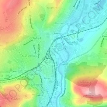
Name: Landore topographic map, elevation, terrain.
Location: Landore, Swansea, Wales, United Kingdom (51.62495 -3.94541 51.65622 -3.92474)
Average elevation: 70 m
Minimum elevation: -4 m
Maximum elevation: 191 m
Other topographic maps
Click on a map to view its topography, its elevation and its terrain.
River Tawe
United Kingdom > Wales > Swansea
River Tawe, Swansea, Wales, SA1 8PH, United Kingdom
Average elevation: 12 m
River Loughor
United Kingdom > Wales > Swansea
River Loughor, Swansea, Wales, SA4 8TL, United Kingdom
Average elevation: 32 m
Clyne River
United Kingdom > Wales > Swansea
Clyne River, Swansea, Wales, SA3 5AT, United Kingdom
Average elevation: 25 m