
Wasatch Range topographic map
Interactive map
Click on the map to display elevation.
About this map
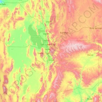
Name: Wasatch Range topographic map, elevation, terrain.
Location: Wasatch Range, Salt Lake County, Utah, USA (38.36966 -111.92048 42.68042 -111.08277)
Average elevation: 1,880 m
Minimum elevation: 1,109 m
Maximum elevation: 4,021 m
Other topographic maps
Click on a map to view its topography, its elevation and its terrain.
Timpanogos Glacier
USA > Utah > Aspen Grove
Timpanogos Glacier, Mount Timpanogos Trail #052, Aspen Grove, Utah County, Utah, USA
Average elevation: 3,148 m
La Sal Mountains Viewpoint
La Sal Mountains Viewpoint, Arches Entrance Road, Grand County, Utah, 84532-2134, USA
Average elevation: 1,347 m
The Craters
USA > Utah > North View
The Craters, State Route 148 (closed winters), North View, Iron County, Utah, USA
Average elevation: 3,125 m