
Dolphin Island topographic map
Interactive map
Click on the map to display elevation.
About this map
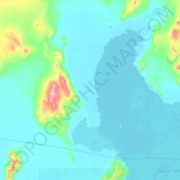
Name: Dolphin Island topographic map, elevation, terrain.
Location: Dolphin Island, Box Elder County, Utah, USA (41.14520 -113.32193 41.78520 -112.68193)
Average elevation: 1,348 m
Minimum elevation: 1,278 m
Maximum elevation: 2,106 m
Other topographic maps
Click on a map to view its topography, its elevation and its terrain.
Timpanogos Glacier
USA > Utah > Aspen Grove
Timpanogos Glacier, Mount Timpanogos Trail #052, Aspen Grove, Utah County, Utah, USA
Average elevation: 3,148 m
La Sal Mountains Viewpoint
La Sal Mountains Viewpoint, Arches Entrance Road, Grand County, Utah, 84532-2134, USA
Average elevation: 1,347 m
The Craters
USA > Utah > North View
The Craters, State Route 148 (closed winters), North View, Iron County, Utah, USA
Average elevation: 3,125 m