
Thank you for supporting this site ❤️
Make a donation
Make a donation
Sioux Narrows topographic map
Click on the map to display elevation.
Thank you for supporting this site ❤️
Make a donation
Make a donation
About this map
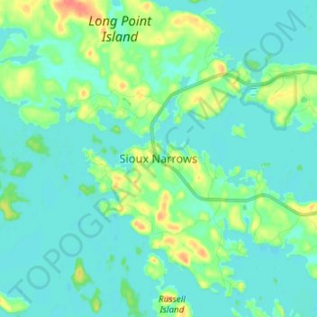
Name: Sioux Narrows topographic map, elevation, terrain.
Average elevation: 329 m
Minimum elevation: 318 m
Maximum elevation: 372 m
Thank you for supporting this site ❤️
Make a donation
Make a donation
Other topographic maps
Click on a map to view its topography, its elevation and its terrain.
Caliper Lake Provincial Park
Canada > Ontario > Kenora District > Sioux Narrows-Nestor Falls Township
Average elevation: 338 m
Sioux Narrows Provincial Park
Canada > Ontario > Kenora District > Sioux Narrows-Nestor Falls Township
Average elevation: 329 m
Squirrel Lake
Canada > Ontario > Kenora District > Sioux Narrows-Nestor Falls Township
Average elevation: 360 m
Berry Lake
Canada > Ontario > Kenora District > Sioux Narrows-Nestor Falls Township
Average elevation: 340 m
Thank you for supporting this site ❤️
Make a donation
Make a donation