
North Somerset topographic map
Interactive map
Click on the map to display elevation.
About this map
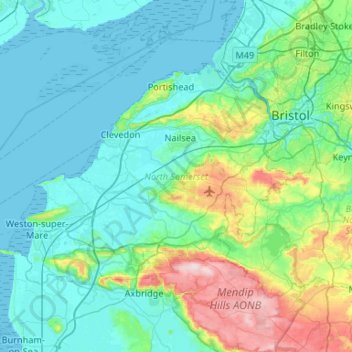
Name: North Somerset topographic map, elevation, terrain.
Location: North Somerset, Zuidwest-Engeland, Engeland, VK (51.29062 -3.11533 51.50269 -2.58720)
Average elevation: 57 m
Minimum elevation: 0 m
Maximum elevation: 324 m
Other topographic maps
Click on a map to view its topography, its elevation and its terrain.
Groot-Brittannië
VK > Engeland > Richmondshire
Groot-Brittannië, Richmondshire, North Yorkshire, Yorkshire and the Humber, Engeland, VK
Average elevation: 52 m
The Cotswolds AONB
The Cotswolds AONB, White Way, North Cerney, Cotswold, Gloucestershire, Zuidwest-Engeland, Engeland, GL7 7DF, VK
Average elevation: 107 m
Lancaster Canal
Lancaster Canal, Lancs, North West England, Engeland, PR2 3XZ, VK
Average elevation: 98 m
Peak District
VK > Engeland > Derbyshire Dales
Peak District, A623, Tideswell CP, Derbyshire Dales, Derbyshire, East Midlands, Engeland, SK17 8RN, VK
Average elevation: 225 m
North Yorkshire
North Yorkshire, Yorkshire and the Humber, Engeland, VK
Average elevation: 153 m
Bathampton
VK > Engeland > Bathampton
Bathampton, Bath and North East Somerset, Zuidwest-Engeland, Engeland, BA2 6, VK
Average elevation: 83 m
Huddersfield Narrow Canal
Huddersfield Narrow Canal, Yorkshire and the Humber, Engeland, HD1 3LE, VK
Average elevation: 312 m
Old Haversham
VK > Engeland > Old Haversham
Old Haversham, Milton Keynes, South East, Engeland, MK19 7DZ, VK
Average elevation: 77 m
Welwyn Hatfield
VK > Engeland > Welwyn Hatfield
Welwyn Hatfield, Hertfordshire, East of England, Engeland, VK
Average elevation: 92 m
South Hams
VK > Engeland > South Hams
South Hams, Devon, Zuidwest-Engeland, Engeland, VK
Average elevation: 98 m
South Lakeland
VK > Engeland > South Lakeland
South Lakeland, Cumbria, North West England, Engeland, VK
Average elevation: 209 m
Chesterfield
VK > Engeland > Chesterfield
Chesterfield, Derbyshire, East Midlands, Engeland, VK
Average elevation: 127 m
Basingstoke and Deane
VK > Engeland > Basingstoke and Deane
Basingstoke and Deane, Hampshire, South East, Engeland, VK
Average elevation: 115 m
Wollaton
VK > Engeland > City of Nottingham > Wollaton
Wollaton, City of Nottingham, East Midlands, Engeland, NG8 2AF, VK
Average elevation: 58 m
Barrow-in-Furness
VK > Engeland > Barrow-in-Furness
Barrow-in-Furness, Cumbria, North West England, Engeland, VK
Average elevation: 22 m
Seaton Carew
VK > Engeland > Seaton Carew
Seaton Carew, Hartlepool, North East England, Engeland, TS25 1BT, VK
Average elevation: 4 m
Newnham
VK > Engeland > Basingstoke and Deane
Newnham, Basingstoke and Deane, Hampshire, South East, Engeland, VK
Average elevation: 82 m
West Kingsdown
West Kingsdown, Sevenoaks, Kent, South East, Engeland, VK
Average elevation: 154 m
Corpusty and Saxthorpe
VK > Engeland > North Norfolk
Corpusty and Saxthorpe, North Norfolk, Norfolk, East of England, Engeland, VK
Average elevation: 44 m
Bickenhill and Marston Green
Bickenhill and Marston Green, Solihull, West Midlands Combined Authority, West Midlands, Engeland, VK
Average elevation: 100 m
Forest of Dean
VK > Engeland > Forest of Dean
Forest of Dean, Gloucestershire, Zuidwest-Engeland, Engeland, VK
Average elevation: 86 m
Trent & Mersey Canal
Trent & Mersey Canal, Staffordshire, West Midlands, Engeland, ST15 8QW, VK
Average elevation: 140 m
Basingstoke Canal
Basingstoke Canal, Runnymede, Surrey, South East, Engeland, KT15 3HJ, VK
Average elevation: 24 m