
Thank you for supporting this site ❤️
Make a donation
Make a donation
Mande topographic map
Click on the map to display elevation.
Thank you for supporting this site ❤️
Make a donation
Make a donation
About this map
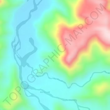
Name: Mande topographic map, elevation, terrain.
Location: Mande, Urrao, Suroeste, Antioquia, Colombia (6.42880 -76.48102 6.44880 -76.46102)
Average elevation: 316 m
Minimum elevation: 209 m
Maximum elevation: 522 m
Thank you for supporting this site ❤️
Make a donation
Make a donation
Other topographic maps
Click on a map to view its topography, its elevation and its terrain.