
Make a donation
Downieville topographic map
Click on the map to display elevation.
Make a donation
Downieville
Downieville is a census-designated place in and the county seat of Sierra County, California, United States. Downieville is on the North Fork of the Yuba River, at an elevation of 2,966 feet (904 m). The 2020 United States census reported Downieville's population was 290.
Make a donation
About this map
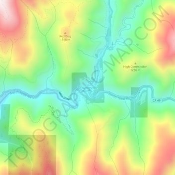
Name: Downieville topographic map, elevation, terrain.
Location: Downieville, Sierra County, California, United States (39.54044 -120.84822 39.58044 -120.80822)
Average elevation: 1,157 m
Minimum elevation: 839 m
Maximum elevation: 1,628 m
Make a donation
Other topographic maps
Click on a map to view its topography, its elevation and its terrain.
Loyalton
United States > California > Sierra County
Loyalton is located at 39°40′36″N 120°14′35″W / 39.67667°N 120.24306°W / 39.67667; -120.24306 (39.676558, -120.243157). Elevation above mean sea level for the area was listed as roughly 4,930 feet (1,500 m). The city is located along California State Route 49, the Gold Country Highway.
Average elevation: 1,514 m