
Thank you for supporting this site ❤️
Make a donation
Make a donation
Kampung Ibok topographic map
Click on the map to display elevation.
Thank you for supporting this site ❤️
Make a donation
Make a donation
About this map
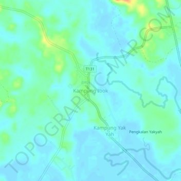
Name: Kampung Ibok topographic map, elevation, terrain.
Location: Kampung Ibok, Kemaman District, Terengganu, Malaysia (4.29997 103.34667 4.33997 103.38667)
Average elevation: 10 m
Minimum elevation: 2 m
Maximum elevation: 41 m
Thank you for supporting this site ❤️
Make a donation
Make a donation
Other topographic maps
Click on a map to view its topography, its elevation and its terrain.
Thank you for supporting this site ❤️
Make a donation
Make a donation
Sungai Kandang Rusa
Malaysia > Terengganu > Kemaman District > Kampung Semayor
Average elevation: 32 m