
Lauricocha topographic map
Interactive map
Click on the map to display elevation.
About this map
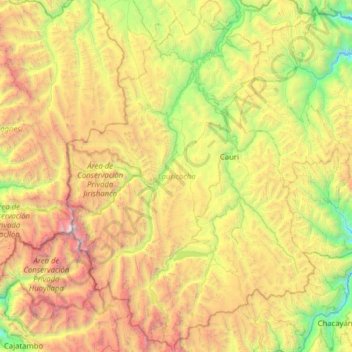
Name: Lauricocha topographic map, elevation, terrain.
Location: Lauricocha, Huánuco, Pérou (-10.48571 -76.91624 -9.86808 -76.47280)
Average elevation: 4,169 m
Minimum elevation: 2,702 m
Maximum elevation: 6,472 m
Other topographic maps
Click on a map to view its topography, its elevation and its terrain.
Lauricocha
Pérou > Huánuco > San Miguel de Cauri
Lauricocha, San Miguel de Cauri, Lauricocha, Huánuco, Pérou
Average elevation: 4,002 m