
Уфимский район topographic map
Interactive map
Click on the map to display elevation.
About this map
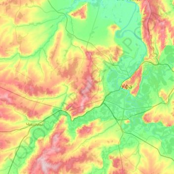
Name: Уфимский район topographic map, elevation, terrain.
Average elevation: 138 m
Minimum elevation: 74 m
Maximum elevation: 281 m
Other topographic maps
Click on a map to view its topography, its elevation and its terrain.
Baschkortostan
Baschkortostan, Föderationskreis Wolga, Russland
Average elevation: 289 m
Belaja
Russland > Baschkortostan > Нугушевский сельсовет
Belaja, Нугушевский сельсовет, Мелеузовский район, Baschkortostan, Föderationskreis Wolga, Russland
Average elevation: 332 m