
Lombok topographic map
Interactive map
Click on the map to display elevation.
About this map
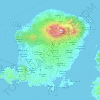
Name: Lombok topographic map, elevation, terrain.
Average elevation: 192 m
Minimum elevation: -1 m
Maximum elevation: 3,605 m
The island's topography is dominated by the centrally-located stratovolcano Mount Rinjani, the second-highest volcano in Indonesia, which rises to 3,726 metres (12,224 ft), making Lombok the 8th-highest island. The most recent eruption of Rinjani occurred in September 2016 at Gunung Barujari. In a 2010 eruption, ash was reported as rising 2 kilometres (1.2 miles) into the atmosphere from the Barujari cone in Rinjani's caldera lake of Segara Anak. Lava flowed into the caldera lake, raising its temperature, while ash fall damaged crops on the slopes of Rinjani. The volcano and its crater lake, Segara Anak (child of the sea), are protected by the Gunung Rinjani National Park established in 1997. Recent evidence indicates an ancient volcano, Mount Samalas, of which now only a caldera remains, was the source of the 1257 Samalas eruption, one of the largest volcanic eruptions in recorded history, which caused worldwide changes in weather.
Other topographic maps
Click on a map to view its topography, its elevation and its terrain.
West Nusa Tenggara
Indonesia > West Nusa Tenggara
West Nusa Tenggara, Indonesia
Average elevation: 31 m
Kabupaten Bima
Indonesia > West Nusa Tenggara
Kabupaten Bima, West Nusa Tenggara, 84171, Indonesia
Average elevation: 90 m
Kecamatan Praya Timur
Indonesia > West Nusa Tenggara > Kecamatan Praya Timur
Kecamatan Praya Timur, Kabupaten Lombok Tengah, West Nusa Tenggara, Indonesia
Average elevation: 155 m