
Thank you for supporting this site ❤️
Make a donation
Make a donation
Alins topographic map
Click on the map to display elevation.
Thank you for supporting this site ❤️
Make a donation
Make a donation
About this map
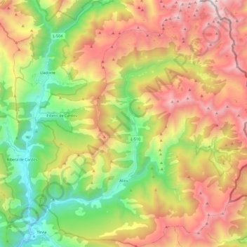
Name: Alins topographic map, elevation, terrain.
Location: Alins, Pallars Sobirà, Lleida, Catalonia, Spain (42.50508 1.24173 42.66900 1.44498)
Average elevation: 1,864 m
Minimum elevation: 823 m
Maximum elevation: 3,116 m
Thank you for supporting this site ❤️
Make a donation
Make a donation
Other topographic maps
Click on a map to view its topography, its elevation and its terrain.
Planell de Malgà
Spain > Catalonia > Pallars Sobirà > Baix Pallars > Gerri de la Sal > Bresca
Average elevation: 764 m
Thank you for supporting this site ❤️
Make a donation
Make a donation
Thank you for supporting this site ❤️
Make a donation
Make a donation