
Jelenia Góra topographic map
Interactive map
Click on the map to display elevation.
About this map
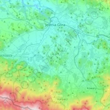
Name: Jelenia Góra topographic map, elevation, terrain.
Location: Jelenia Góra, Lower Silesian Voivodeship, Poland (50.76777 15.57787 50.93256 15.87716)
Average elevation: 518 m
Minimum elevation: 288 m
Maximum elevation: 1,488 m
Other topographic maps
Click on a map to view its topography, its elevation and its terrain.
Wroclaw
Poland > Lower Silesian Voivodeship > Wroclaw
Wroclaw, Lower Silesian Voivodeship, Poland
Average elevation: 124 m
Kłodzko County
Poland > Lower Silesian Voivodeship
Kłodzko County, Lower Silesian Voivodeship, Poland
Average elevation: 509 m
Karkonosze County
Poland > Lower Silesian Voivodeship
Karkonosze County, Lower Silesian Voivodeship, Poland
Average elevation: 606 m
Kłodzko
Poland > Lower Silesian Voivodeship > Kłodzko
Kłodzko, powiat kłodzki, Lower Silesian Voivodeship, 57-300, Poland
Average elevation: 332 m