
Thank you for supporting this site ❤️
Make a donation
Make a donation
Daussois topographic map
Click on the map to display elevation.
Thank you for supporting this site ❤️
Make a donation
Make a donation
Daussois
L'altitude au seuil de l’église est 238 m (point culminant: 290 m) et sa superficie est 773 ha. On dénombrait 582 habitants fin 2011.
Thank you for supporting this site ❤️
Make a donation
Make a donation
About this map
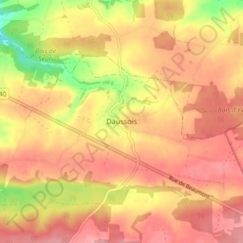
Name: Daussois topographic map, elevation, terrain.
Average elevation: 249 m
Minimum elevation: 180 m
Maximum elevation: 286 m
Thank you for supporting this site ❤️
Make a donation
Make a donation
Other topographic maps
Click on a map to view its topography, its elevation and its terrain.