
Thank you for supporting this site ❤️
Make a donation
Make a donation
North Lima topographic map
Click on the map to display elevation.
Thank you for supporting this site ❤️
Make a donation
Make a donation
About this map
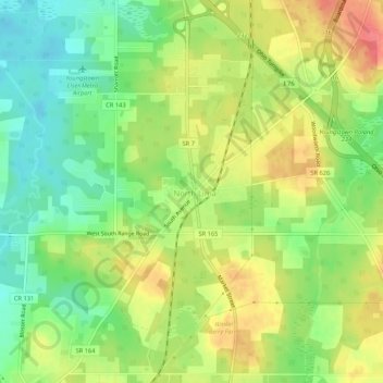
Name: North Lima topographic map, elevation, terrain.
Location: North Lima, Mahoning County, Ohio, 44452, United States (40.92839 -80.67896 40.96839 -80.63896)
Average elevation: 335 m
Minimum elevation: 303 m
Maximum elevation: 372 m
Thank you for supporting this site ❤️
Make a donation
Make a donation
Other topographic maps
Click on a map to view its topography, its elevation and its terrain.
Thank you for supporting this site ❤️
Make a donation
Make a donation
Thank you for supporting this site ❤️
Make a donation
Make a donation
Juliana Kurinka Play Area
United States > Ohio > Mahoning County > Youngstown
Average elevation: 303 m
Thank you for supporting this site ❤️
Make a donation
Make a donation