
Make a donation
Levens topographic map
Click on the map to display elevation.
Make a donation
Levens
The village, built on high rocky ground, is located at an altitude of 600 metres. It lies in the centre of the district, which stretches from the plain of the Var (Plan-du-Var hamlet) to the Férion range. Mount Férion is 1,400 metres high.
Make a donation
About this map
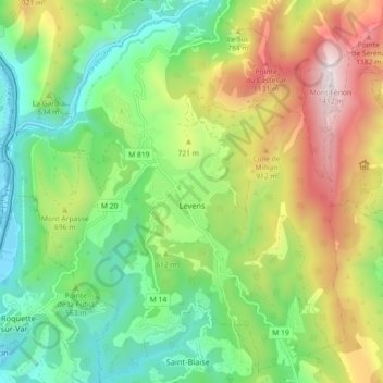
Name: Levens topographic map, elevation, terrain.
Average elevation: 594 m
Minimum elevation: 118 m
Maximum elevation: 1,398 m
Make a donation
Other topographic maps
Click on a map to view its topography, its elevation and its terrain.
Mont Agel
France > Provence-Alpes-Côte d'Azur > Maritime Alps > Peille
Mont Agel is a mountain in the Maritime Alps on the border between France and Monaco. The summit of this mount, at 1,148 metres (3,766 ft) above sea level, is on the French side, but the highest point of Monaco, lying on a pathway named Chemin des Révoires, is on its slopes, at an altitude of 161 metres (528…
Average elevation: 790 m
La Redoute des 3 Communes
France > Provence-Alpes-Côte d'Azur > Maritime Alps > Moulinet
Average elevation: 1,739 m
Make a donation
Make a donation
Col de Turini
France > Provence-Alpes-Côte d'Azur > Maritime Alps > Moulinet
Average elevation: 1,549 m
Puget-Théniers
France > Provence-Alpes-Côte d'Azur > Maritime Alps > Puget-Théniers
Average elevation: 688 m
Make a donation
Gorgia
France > Provence-Alpes-Côte d'Azur > Maritime Alps > Saint-Étienne-de-Tinée
Average elevation: 1,513 m
Auron
France > Provence-Alpes-Côte d'Azur > Maritime Alps > Saint-Étienne-de-Tinée
Auron is a ski resort in the department of Alpes-Maritimes and the region of Provence-Alpes-Côte d'Azur in France. The resort has 135 kilometres (84 mi) of ski runs, at an elevation of between 1,600 and 2,450 m (5,250 and 8,040 ft) in the French Alps. It is located above the Tinée Valley near the town of…
Average elevation: 1,654 m
Sainte-Claire
France > Provence-Alpes-Côte d'Azur > Maritime Alps > Guillaumes
Average elevation: 1,063 m
Make a donation
La Madone
France > Provence-Alpes-Côte d'Azur > Maritime Alps > Saint-Martin-Vésubie
Average elevation: 1,151 m
Mont Agel
France > Provence-Alpes-Côte d'Azur > Maritime Alps > Peille
Mont Agel is a mountain on the border between France and Monaco. The summit of this mount, at 1,148 metres (3,766 ft) above sea level, is on the French side, but the highest point of Monaco, lying on a pathway named Chemin des Révoires, is on its slopes, at an altitude of 161 metres (528 feet).
Average elevation: 790 m
Make a donation
Make a donation
Réca Véssas
France > Provence-Alpes-Côte d'Azur > Maritime Alps > Clans > Bancairon
Average elevation: 625 m