
Thank you for supporting this site ❤️
Make a donation
Make a donation
Standish topographic map
Click on the map to display elevation.
Thank you for supporting this site ❤️
Make a donation
Make a donation
About this map
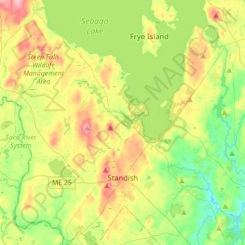
Name: Standish topographic map, elevation, terrain.
Location: Standish, Cumberland County, Maine, 04084, United States (43.68711 -70.66823 43.86404 -70.44652)
Average elevation: 88 m
Minimum elevation: 26 m
Maximum elevation: 188 m
Thank you for supporting this site ❤️
Make a donation
Make a donation
Other topographic maps
Click on a map to view its topography, its elevation and its terrain.
Cliff Island
United States > Maine > Cumberland County > Portland > Cliff Island
Average elevation: 1 m
Thank you for supporting this site ❤️
Make a donation
Make a donation
Thank you for supporting this site ❤️
Make a donation
Make a donation