
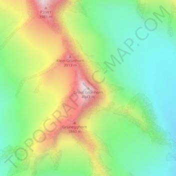
Gross Grünhorn topographic map
Interactive map
Click on the map to display elevation.
About this map
Name: Gross Grünhorn topographic map, elevation, terrain.
Location: Gross Grünhorn, Fieschertal, Conches, Valais, Suisse (46.53198 8.07772 46.53208 8.07782)
Average elevation: 3,432 m
Minimum elevation: 3,077 m
Maximum elevation: 3,996 m
Other topographic maps
Click on a map to view its topography, its elevation and its terrain.
Jungfraujoch
Suisse > Valais > Fieschertal
Jungfraujoch, Fieschertal, Conches, Valais, 3801, Suisse
Average elevation: 3,307 m
Finsteraarhorn
Suisse > Valais > Fieschertal
Finsteraarhorn, Fieschertal, Conches, Valais, Suisse
Average elevation: 3,420 m