
Thank you for supporting this site ❤️
Make a donation
Make a donation
Othón P. Blanco topographic map
Click on the map to display elevation.
Thank you for supporting this site ❤️
Make a donation
Make a donation
About this map
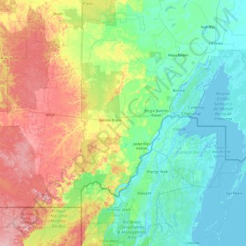
Name: Othón P. Blanco topographic map, elevation, terrain.
Location: Othón P. Blanco, Quintana Roo, Mexico (17.89403 -89.20741 18.98048 -87.29832)
Average elevation: 96 m
Minimum elevation: -3 m
Maximum elevation: 403 m
Thank you for supporting this site ❤️
Make a donation
Make a donation
Other topographic maps
Click on a map to view its topography, its elevation and its terrain.
Thank you for supporting this site ❤️
Make a donation
Make a donation
Presidente Juárez
Mexico > Quintana Roo > Felipe Carrillo Puerto > Presidente Juárez
Average elevation: 23 m