
Thank you for supporting this site ❤️
Make a donation
Make a donation
Kuranchery topographic map
Click on the map to display elevation.
Thank you for supporting this site ❤️
Make a donation
Make a donation
About this map
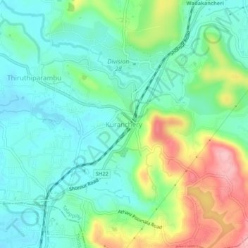
Name: Kuranchery topographic map, elevation, terrain.
Location: Kuranchery, Talappilly, Thrissur, Kerala, 680623, India (10.61066 76.20634 10.65066 76.24634)
Average elevation: 60 m
Minimum elevation: 12 m
Maximum elevation: 170 m
Thank you for supporting this site ❤️
Make a donation
Make a donation
Other topographic maps
Click on a map to view its topography, its elevation and its terrain.
Sreekumar,Kalathil Veedu, Kumbalangad Vaka Kulam 2
India > Kerala > Talappilly
Average elevation: 39 m
Thank you for supporting this site ❤️
Make a donation
Make a donation
Thank you for supporting this site ❤️
Make a donation
Make a donation