
Isabella County topographic map
Interactive map
Click on the map to display elevation.
About this map
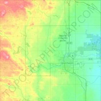
Name: Isabella County topographic map, elevation, terrain.
Location: Isabella County, Michigan, United States of America (43.46593 -85.08881 43.81526 -84.60602)
Average elevation: 261 m
Minimum elevation: 207 m
Maximum elevation: 380 m
Other topographic maps
Click on a map to view its topography, its elevation and its terrain.
Van Buren County
United States of America > Michigan
Hamilton Township, Van Buren County, Michigan, United States of America
Average elevation: 237 m
Lake Saint Clair
United States of America > Michigan
Lake Saint Clair, Macomb County, Michigan, United States of America
Average elevation: 177 m
Genesee County
United States of America > Michigan
Genesee County, Michigan, United States of America
Average elevation: 246 m
Mackinac County
United States of America > Michigan
Mackinac County, Michigan, United States of America
Average elevation: 206 m
Ann Arbor
United States of America > Michigan > Ann Arbor
Ann Arbor, Washtenaw County, Michigan, United States of America
Average elevation: 268 m
Portage
United States of America > Michigan > Portage
Portage, Kalamazoo County, Michigan, United States of America
Average elevation: 266 m
Baraga County
United States of America > Michigan
Baraga County, Michigan, United States of America
Average elevation: 378 m
Ontonagon County
United States of America > Michigan
Ontonagon County, Michigan, United States of America
Average elevation: 334 m
Washtenaw County
United States of America > Michigan
Washtenaw County, Michigan, United States of America
Average elevation: 267 m
Sanilac County
United States of America > Michigan
Sanilac County, Michigan, United States of America
Average elevation: 228 m