
Esborn topographic map
Interactive map
Click on the map to display elevation.
About this map
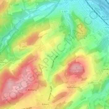
Name: Esborn topographic map, elevation, terrain.
Average elevation: 162 m
Minimum elevation: 83 m
Maximum elevation: 248 m
Other topographic maps
Click on a map to view its topography, its elevation and its terrain.
Wengern
Deutschland > Nordrhein-Westfalen > Wetter (Ruhr)
Wengern, Wetter (Ruhr), Ennepe-Ruhr-Kreis, Regierungsbezirk Arnsberg, Nordrhein-Westfalen, Deutschland
Average elevation: 154 m