
Make a donation
Monroe County topographic map
Click on the map to display elevation.
Make a donation
Monroe County
Monroe County features a diverse topography characterized by rolling hills, flat plains, and numerous water bodies, including Lake Ontario to the north. The terrain rises gently from the shores of the lake, with elevations reaching approximately 800 feet (244 meters) in the southern regions, particularly near the escarpment of the Appalachian Mountains. This varying elevation contributes to a unique landscape, dotted with valleys, ravines, and wetlands, which are home to a rich array of ecosystems. The county's extensive park system showcases these natural features, providing opportunities for outdoor recreation amid scenic views. The area is also shaped by glacial activity, which has carved out distinct landforms and left behind rich soils ideal for agriculture.
Make a donation
About this map
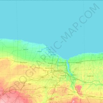
Name: Monroe County topographic map, elevation, terrain.
Location: Monroe County, New York, United States (42.93991 -78.00899 43.63475 -77.37128)
Average elevation: 122 m
Minimum elevation: 72 m
Maximum elevation: 339 m
Make a donation
Other topographic maps
Click on a map to view its topography, its elevation and its terrain.
Central Park
United States > New York > New York County > New York
In June 1856, Fernando Wood appointed a "consulting board" of seven people, headed by author Washington Irving, to inspire public confidence in the proposed development. Wood hired military engineer Egbert Ludovicus Viele as the park's chief engineer, tasking him with a topographical survey of the site. The…
Average elevation: 26 m
Brooklyn Bridge Park
United States > New York > Kings County > New York
Brooklyn Bridge Park spans 85 acres (34 ha) of the East River waterfront in the Brooklyn Heights and Dumbo neighborhoods of Brooklyn. The park is divided into eleven sections: Piers 1 through 6; Fulton Ferry Landing; Brooklyn Bridge Plaza; Empire Fulton Ferry; Main Street; and John Street. Each of these…
Average elevation: 9 m
Mount Marcy
United States > New York > Essex County > Town of Keene
Mount Marcy is the highest point in the Adirondack Mountains and the U.S. state of New York, with an elevation of 5,343.1 feet (1,628.6 m). It is located in the town of Keene in Essex County. The mountain is in the heart of the High Peaks Wilderness Area in Adirondack Park. Like the surrounding Adirondack…
Average elevation: 1,289 m
Make a donation
Catskill mountains view
United States > New York > Greene County > Town of Hunter
Average elevation: 740 m
Inwood Hill Park
United States > New York > New York County > New York
Inwood Hill Park is a 196 acres (79 ha) public park in the Inwood neighborhood of Manhattan, New York City, operated by the New York City Department of Parks and Recreation. On a high schist ridge that rises 200 feet (61 m) above the Hudson River from Dyckman Street to the northern tip of the island, Inwood…
Average elevation: 14 m
Make a donation
Make a donation
East Poestenkill
United States > New York > Rensselaer County > Town of Poestenkill
Average elevation: 376 m
Make a donation
Make a donation
Chenango Lake
United States > New York > Chenango County > Town of New Berlin
Average elevation: 513 m
Make a donation
Tusten Mountain Lake
United States > New York > Sullivan County > Town of Tusten
Average elevation: 346 m
North Germantown
United States > New York > Columbia County > Town of Germantown
Average elevation: 34 m
Hoopers Valley Island
United States > New York > Tioga County > Hoopers Valley
Average elevation: 267 m
Make a donation
Tug Hill
United States > New York > Oswego County
The core Tug Hill region encompasses 150,000 acres (610 km2) of unbroken, generally second-growth, northern hardwood forest, and is drained by a vast network of streams. Important rivers and streams whose headwaters are located within the Tug Hill region include the Mohawk River, Deer River, Salmon River, Mad…
Average elevation: 109 m
Barberville
United States > New York > Rensselaer County > Town of Poestenkill
Average elevation: 269 m
Make a donation
Make a donation
Make a donation
Big Bad Luck Pond
United States > New York > Hamilton County > Town of Indian Lake
Average elevation: 539 m
Make a donation
Woodcock Mountain
United States > New York > Saratoga County > Town of Hadley
Average elevation: 271 m
Make a donation
Constantia Center
United States > New York > Oswego County > Town of Constantia
Average elevation: 169 m
South New Berlin
United States > New York > Chenango County > Town of New Berlin
Average elevation: 380 m
Make a donation
Coney Island
United States > New York > Saint Lawrence County > Town of Pierrepont
Average elevation: 174 m
Make a donation
Make a donation
Make a donation
Make a donation
Sunset Ridge
United States > New York > Westchester County > Town/Village of Harrison
Average elevation: 27 m
Make a donation
Ellicottville
United States > New York > Cattaraugus County > Village of Ellicottville
Average elevation: 573 m
Make a donation
Make a donation
Niagara Escarpment
United States > New York > Niagara County > City of Lockport
Average elevation: 149 m
Ellenburg Mountain
United States > New York > Clinton County > Town of Ellenburg
Average elevation: 682 m
Make a donation
Make a donation
Make a donation
Make a donation
Make a donation