
Thank you for supporting this site ❤️
Make a donation
Make a donation
Mount Spearing topographic map
Click on the map to display elevation.
Thank you for supporting this site ❤️
Make a donation
Make a donation
About this map
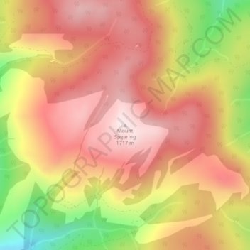
Name: Mount Spearing topographic map, elevation, terrain.
Average elevation: 1,534 m
Minimum elevation: 1,239 m
Maximum elevation: 1,711 m
Thank you for supporting this site ❤️
Make a donation
Make a donation
Other topographic maps
Click on a map to view its topography, its elevation and its terrain.
Hall Lake
Canada > British Columbia > Regional District of Okanagan-Similkameen > Area H (Manning Park/Tulameen/Siwash)
Average elevation: 1,178 m