
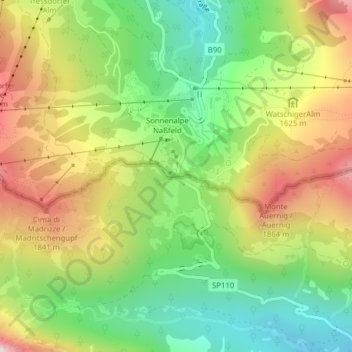
Nassfeld topographic map
Interactive map
Click on the map to display elevation.
About this map
Name: Nassfeld topographic map, elevation, terrain.
Location: Nassfeld, Pontafel, Udine, Friaul-Julisch Venetien, Italien (46.55991 13.27551 46.56001 13.27561)
Average elevation: 1,572 m
Minimum elevation: 1,268 m
Maximum elevation: 1,965 m
Das Nassfeld (slowenisch Mokrine, italienisch Passo di Pramollo) in den Karnischen Alpen ist ein Sattel zwischen dem österreichischen Gail- und dem italienischen Kanaltal. Die Passhöhe liegt auf 1530 m ü. A., umliegende Berge sind der Gartnerkofel (2195 m), der Rosskofel (2239 m) und der Trogkofel (2280 m). Der Gartnerkofel ist bekannt für das Vorkommen des Kuhtritts, einer seltenen und endemischen Bergblume.
Other topographic maps
Click on a map to view its topography, its elevation and its terrain.
Thurm
Italien > Friaul-Julisch Venetien > Udine > Pontafel
Thurm, Pontafel, Udine, Friaul-Julisch Venetien, Italien
Average elevation: 1,400 m