
Thank you for supporting this site ❤️
Make a donation
Make a donation
Luberri topographic map
Click on the map to display elevation.
Thank you for supporting this site ❤️
Make a donation
Make a donation
About this map
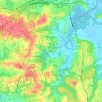
Name: Luberri topographic map, elevation, terrain.
Average elevation: 37 m
Minimum elevation: -3 m
Maximum elevation: 87 m
Thank you for supporting this site ❤️
Make a donation
Make a donation
Other topographic maps
Click on a map to view its topography, its elevation and its terrain.
64200
France > Nouvelle-Aquitaine > Pyrénées-Atlantiques > Bassussarry > Luberri
Average elevation: 36 m