
Make a donation
Bellefontaine topographic map
Click on the map to display elevation.
Make a donation
Bellefontaine
The city of Bellefontaine is at the convergence of the humid subtropical (Köppen Cfa) and humid continental (Köppen Dfa) climate zones according to the Köppen climate map. The region is characterized by four distinct seasons. Winters are cool to cold with mild periods, and summers are generally hot and muggy, with significant precipitation year-round. The city is too far south to experience lake effect snow from the Great Lakes region, however it does experience more snow than surrounding areas due to the city's elevation. Traditionally, Bellefontaine's elevation excludes it from tornadoes and floods that affect the majority of the Miami Valley.
Make a donation
About this map
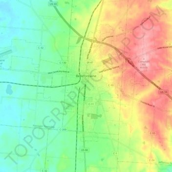
Name: Bellefontaine topographic map, elevation, terrain.
Average elevation: 384 m
Minimum elevation: 326 m
Maximum elevation: 471 m
Make a donation
Other topographic maps
Click on a map to view its topography, its elevation and its terrain.