
Thank you for supporting this site ❤️
Make a donation
Make a donation
Groß Wittensee topographic map
Click on the map to display elevation.
Thank you for supporting this site ❤️
Make a donation
Make a donation
About this map
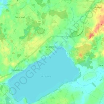
Name: Groß Wittensee topographic map, elevation, terrain.
Average elevation: 17 m
Minimum elevation: 1 m
Maximum elevation: 57 m
Thank you for supporting this site ❤️
Make a donation
Make a donation
Other topographic maps
Click on a map to view its topography, its elevation and its terrain.
Ernsttal
Duitsland > Sleeswijk-Holstein > Rendsburg-Eckernförde > Fockbek > Ernsttal
Average elevation: 14 m