
Sevenoaks topographic map
Interactive map
Click on the map to display elevation.
About this map
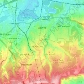
Name: Sevenoaks topographic map, elevation, terrain.
Location: Sevenoaks, Kent, South East, Angleterre, Royaume-Uni (51.24917 0.17035 51.30013 0.22526)
Average elevation: 127 m
Minimum elevation: 62 m
Maximum elevation: 218 m
Other topographic maps
Click on a map to view its topography, its elevation and its terrain.
Crockenhill
Royaume-Uni > Angleterre > Sevenoaks
Crockenhill, Sevenoaks, Kent, South East, Angleterre, Royaume-Uni
Average elevation: 96 m