
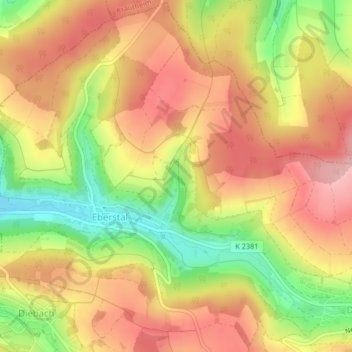
Tadle topographic map
Interactive map
Click on the map to display elevation.
About this map
Name: Tadle topographic map, elevation, terrain.
Average elevation: 352 m
Minimum elevation: 261 m
Maximum elevation: 418 m
Other topographic maps
Click on a map to view its topography, its elevation and its terrain.
Tadle
Allemagne > Bade-Wurtemberg > Ingelfingen
Tadle, Ingelfingen, Verwaltungsgemeinschaft Künzelsau, Hohenlohekreis, Regierungsbezirk Stuttgart, Bade-Wurtemberg, 74238, Allemagne
Average elevation: 353 m