
Thank you for supporting this site ❤️
Make a donation
Make a donation
Can-untog topographic map
Click on the map to display elevation.
Thank you for supporting this site ❤️
Make a donation
Make a donation
About this map
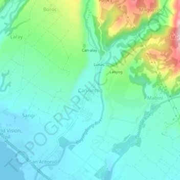
Name: Can-untog topographic map, elevation, terrain.
Location: Can-untog, Ormoc, Leyte, Eastern Visayas, Philippines (10.96162 124.63732 11.00162 124.67732)
Average elevation: 51 m
Minimum elevation: 0 m
Maximum elevation: 209 m
Thank you for supporting this site ❤️
Make a donation
Make a donation
Other topographic maps
Click on a map to view its topography, its elevation and its terrain.