
Thank you for supporting this site ❤️
Make a donation
Make a donation
Baulmes topographic map
Click on the map to display elevation.
Thank you for supporting this site ❤️
Make a donation
Make a donation
About this map
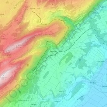
Name: Baulmes topographic map, elevation, terrain.
Location: Baulmes, District du Jura-Nord vaudois, Vaud, 1446, Switzerland (46.76747 6.43479 46.80995 6.55213)
Average elevation: 827 m
Minimum elevation: 429 m
Maximum elevation: 1,581 m
Thank you for supporting this site ❤️
Make a donation
Make a donation
Other topographic maps
Click on a map to view its topography, its elevation and its terrain.