
Thank you for supporting this site ❤️
Make a donation
Make a donation
Crouttes-sur-Marne topographic map
Click on the map to display elevation.
Thank you for supporting this site ❤️
Make a donation
Make a donation
About this map
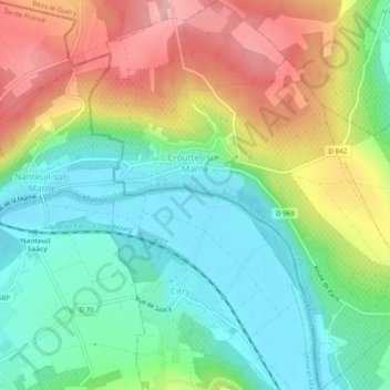
Name: Crouttes-sur-Marne topographic map, elevation, terrain.
Average elevation: 113 m
Minimum elevation: 52 m
Maximum elevation: 208 m
Thank you for supporting this site ❤️
Make a donation
Make a donation
Other topographic maps
Click on a map to view its topography, its elevation and its terrain.
Saint-Quentin
France > Hauts-de-France > Aisne > Saint-Quentin > Saint-Quentin
Average elevation: 99 m