
Make a donation
Bee Island topographic map
Click on the map to display elevation.
Make a donation
About this map
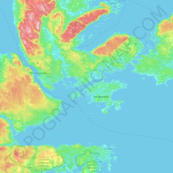
Name: Bee Island topographic map, elevation, terrain.
Average elevation: 43 m
Minimum elevation: -3 m
Maximum elevation: 303 m
Make a donation
Other topographic maps
Click on a map to view its topography, its elevation and its terrain.
Bras d'Or Lake
Canada > Nova Scotia > Municipality of the County of Richmond > Red Islands
Average elevation: 29 m
Make a donation
Lennox Passage Provincial Park
Canada > Nova Scotia > Municipality of the County of Richmond > Martinique
Average elevation: 7 m
Make a donation
Make a donation
Garrets Lake
Canada > Nova Scotia > Municipality of the County of Richmond > Salmon River
Average elevation: 48 m
Make a donation
Barachois Pond
Canada > Nova Scotia > Municipality of the County of Richmond > Arichat
Average elevation: 16 m
Make a donation
St. Marys
Canada > Nova Scotia > Municipality of the County of Richmond > St. Marys
Average elevation: 9 m
Sampson Lake
Canada > Nova Scotia > Municipality of the County of Richmond > Louisdale
Average elevation: 7 m
Make a donation
Make a donation