
Thank you for supporting this site ❤️
Make a donation
Make a donation
Black Rock Desert topographic map
Click on the map to display elevation.
Thank you for supporting this site ❤️
Make a donation
Make a donation
About this map
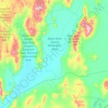
Name: Black Rock Desert topographic map, elevation, terrain.
Location: Black Rock Desert, Nevada, United States of America (40.62060 -119.38426 41.54571 -118.44859)
Average elevation: 1,445 m
Minimum elevation: 1,186 m
Maximum elevation: 2,744 m
Thank you for supporting this site ❤️
Make a donation
Make a donation
Other topographic maps
Click on a map to view its topography, its elevation and its terrain.
Incline Village
United States of America > Nevada > Incline Village > Incline Village
Average elevation: 2,175 m