
Sankt Hubert topographic map
Interactive map
Click on the map to display elevation.
About this map
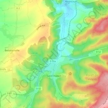
Name: Sankt Hubert topographic map, elevation, terrain.
Average elevation: 261 m
Minimum elevation: 194 m
Maximum elevation: 352 m
Die Gemeinde Saint-Hubert liegt an der Canner, etwa fünf Kilometer östlich der Mosel zwischen Metz und Thionville auf einer mittleren Höhe von 217 m. Das Gemeindegebiet umfasst 16,04 km².
Other topographic maps
Click on a map to view its topography, its elevation and its terrain.
Kleinrosseln
Frankreich > Grand Est > Mosel
Kleinrosseln, Forbach-Bolchen, Mosel, Grand Est, Metropolitanes Frankreich, 57540, Frankreich
Average elevation: 244 m
Alberschweiler
Frankreich > Grand Est > Mosel
Alberschweiler, Sarrebourg-Château-Salins, Mosel, Grand Est, Metropolitanes Frankreich, 57560, Frankreich
Average elevation: 422 m
Tressingen
Frankreich > Grand Est > Mosel
Tressingen, Diedenhofen, Mosel, Grand Est, Metropolitanes Frankreich, 57710, Frankreich
Average elevation: 359 m
Hattingen
Frankreich > Grand Est > Mosel
Hattingen, Sarrebourg-Château-Salins, Mosel, Grand Est, Metropolitanes Frankreich, 57790, Frankreich
Average elevation: 325 m
Willingen
Frankreich > Grand Est > Mosel
Willingen, Forbach-Bolchen, Mosel, Grand Est, Metropolitanes Frankreich, 57550, Frankreich
Average elevation: 287 m
Mondorf
Frankreich > Grand Est > Mosel
Mondorf, Diedenhofen, Mosel, Grand Est, Metropolitanes Frankreich, 57570, Frankreich
Average elevation: 234 m
Burscheid
Frankreich > Grand Est > Mosel
Burscheid, Sarrebourg-Château-Salins, Mosel, Grand Est, Metropolitanes Frankreich, 57370, Frankreich
Average elevation: 298 m
Metz
Frankreich > Grand Est > Mosel
Metz, Mosel, Grand Est, Metropolitanes Frankreich, Frankreich
Average elevation: 196 m