Geolocate

Barry topographic map

Click on the map to display elevation.

About this map

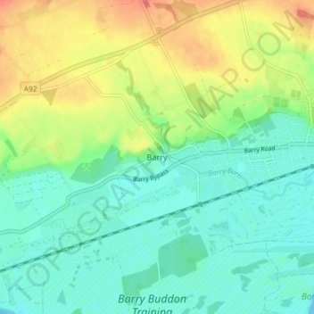
Name: Barry topographic map, elevation, terrain.

Location: Barry, Angus, Scotland, DD7 7RF, United Kingdom (56.47913 -2.77612 56.51913 -2.73612)

Average elevation: 22 m

Minimum elevation: 0 m

Maximum elevation: 65 m

Other topographic maps

Click on a map to view its topography, its elevation and its terrain.

River North Esk

United Kingdom > Scotland > Angus

Average elevation: 204 m

River South Esk

United Kingdom > Scotland > Angus

Average elevation: 287 m

Forter Castle

United Kingdom > Scotland > Angus > Folda

Average elevation: 387 m

Glen Dye

United Kingdom > Scotland > Angus

Average elevation: 416 m

Forter Castle

United Kingdom > Scotland > Angus > Folda

Average elevation: 387 m

Loch Brandy

United Kingdom > Scotland > Angus

Average elevation: 691 m

Sand Martins

United Kingdom > Scotland > Angus > Forfar

Average elevation: 97 m

Glamis Castle

United Kingdom > Scotland > Angus > Forfar > Deanbank

Average elevation: 69 m

Loch Brandy

United Kingdom > Scotland > Angus

Average elevation: 691 m

Glen Lethnot

United Kingdom > Scotland > Angus

Average elevation: 365 m

Edzell Castle

United Kingdom > Scotland > Angus > Little Brechin

Average elevation: 98 m

Forfar

United Kingdom > Scotland > Angus

Average elevation: 95 m

Glen Isla

United Kingdom > Scotland > Angus > Kirkton of Glenisla

Average elevation: 430 m

Glen Esk

United Kingdom > Scotland > Angus > Tarfside

Average elevation: 329 m

Glen Doll

United Kingdom > Scotland > Angus

Average elevation: 625 m