
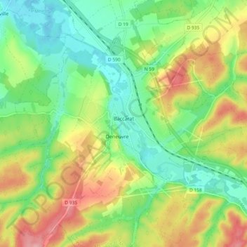
Baccarat topographic map
Interactive map
Click on the map to display elevation.
About this map
Name: Baccarat topographic map, elevation, terrain.
Average elevation: 304 m
Minimum elevation: 252 m
Maximum elevation: 382 m
Other topographic maps
Click on a map to view its topography, its elevation and its terrain.
Tonnoy
France > Grand Est > Meurthe-et-Moselle
Tonnoy, Nancy, Meurthe-et-Moselle, Grand Est, France métropolitaine, 54210, France
Average elevation: 290 m
Villey-le-Sec
France > Grand Est > Meurthe-et-Moselle
Villey-le-Sec, Toul, Meurthe-et-Moselle, Grand Est, France métropolitaine, 54840, France
Average elevation: 277 m
Houdemont
France > Grand Est > Meurthe-et-Moselle
Houdemont, Nancy, Meurthe-et-Moselle, Grand Est, France métropolitaine, 54180, France
Average elevation: 304 m
Serres
France > Grand Est > Meurthe-et-Moselle
Serres, Lunéville, Meurthe-et-Moselle, Grand Est, France métropolitaine, 54370, France
Average elevation: 272 m
La Madeleine
France > Grand Est > Meurthe-et-Moselle > Laneuveville-devant-Nancy
La Madeleine, Laneuveville-devant-Nancy, Nancy, Meurthe-et-Moselle, Grand Est, France métropolitaine, 54410, France
Average elevation: 224 m
l'Avrima
France > Grand Est > Meurthe-et-Moselle > Blénod-lès-Pont-à-Mousson
l'Avrima, Blénod-lès-Pont-à-Mousson, Nancy, Meurthe-et-Moselle, Grand Est, France métropolitaine, 54700, France
Average elevation: 203 m
Liverdun
France > Grand Est > Meurthe-et-Moselle
Liverdun, Nancy, Meurthe-et-Moselle, Grand Est, France métropolitaine, 54460, France
Average elevation: 280 m
Briey
France > Grand Est > Meurthe-et-Moselle > Val de Briey
Briey, Val de Briey, Val-de-Briey, Meurthe-et-Moselle, Grand Est, France métropolitaine, 54150, France
Average elevation: 256 m
Blâmont
France > Grand Est > Meurthe-et-Moselle
Blâmont, Lunéville, Meurthe-et-Moselle, Grand Est, France métropolitaine, 54450, France
Average elevation: 288 m
Villers-lès-Nancy
France > Grand Est > Meurthe-et-Moselle
Villers-lès-Nancy, Nancy, Meurthe-et-Moselle, Grand Est, France métropolitaine, 54600, France
Average elevation: 307 m
Courcelles
France > Grand Est > Meurthe-et-Moselle
Courcelles, Toul, Meurthe-et-Moselle, Grand Est, France métropolitaine, 54930, France
Average elevation: 338 m
Varangéville
France > Grand Est > Meurthe-et-Moselle
Varangéville, Nancy, Meurthe-et-Moselle, Grand Est, France métropolitaine, 54110, France
Average elevation: 240 m
Toul
France > Grand Est > Meurthe-et-Moselle
Toul, Meurthe-et-Moselle, Grand Est, France métropolitaine, 54200, France
Average elevation: 245 m
Vandœuvre-lès-Nancy
France > Grand Est > Meurthe-et-Moselle
Vandœuvre-lès-Nancy, Nancy, Meurthe-et-Moselle, Grand Est, France métropolitaine, 54500, France
Average elevation: 273 m
Dieulouard
France > Grand Est > Meurthe-et-Moselle
Dieulouard, Nancy, Meurthe-et-Moselle, Grand Est, France métropolitaine, 54380, France
Average elevation: 226 m
Champigneulles
France > Grand Est > Meurthe-et-Moselle
Champigneulles, Nancy, Meurthe-et-Moselle, Grand Est, France métropolitaine, 54250, France
Average elevation: 270 m
Maron
France > Grand Est > Meurthe-et-Moselle
Maron, Nancy, Meurthe-et-Moselle, Grand Est, France métropolitaine, 54230, France
Average elevation: 318 m
Moutiers
France > Grand Est > Meurthe-et-Moselle
Moutiers, Val-de-Briey, Meurthe-et-Moselle, Grand Est, France métropolitaine, 54660, France
Average elevation: 239 m
Saint-Martin
France > Grand Est > Meurthe-et-Moselle
Saint-Martin, Lunéville, Meurthe-et-Moselle, Grand Est, France métropolitaine, 54450, France
Average elevation: 262 m
Auboué
France > Grand Est > Meurthe-et-Moselle
Auboué, Briey, Meurthe-et-Moselle, Grand Est, France métropolitaine, 54580, France
Average elevation: 220 m
Nancy
France > Grand Est > Meurthe-et-Moselle
Nancy, Meurthe-et-Moselle, Grand Est, France métropolitaine, France
Average elevation: 230 m