
Thank you for supporting this site ❤️
Make a donation
Make a donation
Imbil topographic map
Click on the map to display elevation.
Thank you for supporting this site ❤️
Make a donation
Make a donation
About this map
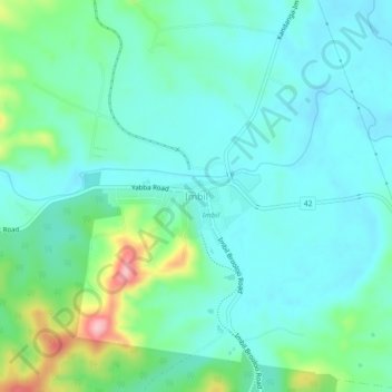
Name: Imbil topographic map, elevation, terrain.
Location: Imbil, Gympie Regional, Queensland, 4570, Australia (-26.48049 152.65631 -26.44049 152.69631)
Average elevation: 109 m
Minimum elevation: 72 m
Maximum elevation: 240 m
Thank you for supporting this site ❤️
Make a donation
Make a donation
Other topographic maps
Click on a map to view its topography, its elevation and its terrain.