
Oberegg topographic map
Interactive map
Click on the map to display elevation.
About this map
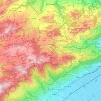
Name: Oberegg topographic map, elevation, terrain.
Location: Oberegg, Appenzell Rhodes-Intérieures, 9413, Suisse (47.39308 9.50820 47.44369 9.61840)
Average elevation: 779 m
Minimum elevation: 405 m
Maximum elevation: 1,169 m
Other topographic maps
Click on a map to view its topography, its elevation and its terrain.
Ebenalp
Suisse > Appenzell Rhodes-Intérieures > Schwende-Rüte
Ebenalp, Schwende, Schwende-Rüte, Appenzell Rhodes-Intérieures, 9057, Suisse
Average elevation: 1,233 m
Seealpsee
Suisse > Appenzell Rhodes-Intérieures > Schwende-Rüte
Seealpsee, Schwende, Schwende-Rüte, Appenzell Rhodes-Intérieures, 9057, Suisse
Average elevation: 1,492 m
Appenzell
Suisse > Appenzell Rhodes-Intérieures
Appenzell, Appenzell Rhodes-Intérieures, 9050, Suisse
Average elevation: 940 m