
Thank you for supporting this site ❤️
Make a donation
Make a donation
La Porte topographic map
Click on the map to display elevation.
Thank you for supporting this site ❤️
Make a donation
Make a donation
About this map
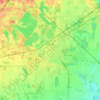
Name: La Porte topographic map, elevation, terrain.
Location: La Porte, LaPorte County, Indiana, 46350, United States (41.56135 -86.76490 41.66896 -86.67080)
Average elevation: 249 m
Minimum elevation: 226 m
Maximum elevation: 280 m
Thank you for supporting this site ❤️
Make a donation
Make a donation
Other topographic maps
Click on a map to view its topography, its elevation and its terrain.