
Sollstedt topographic map
Interactive map
Click on the map to display elevation.
About this map
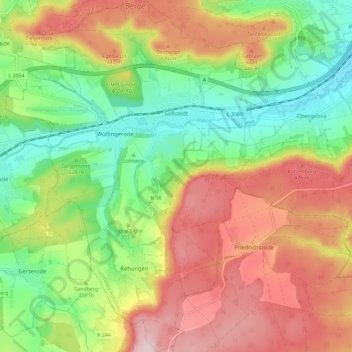
Name: Sollstedt topographic map, elevation, terrain.
Location: Sollstedt, Landkreis Nordhausen, Thüringen, Duitsland (51.36485 10.47056 51.43640 10.56117)
Average elevation: 366 m
Minimum elevation: 233 m
Maximum elevation: 525 m
Other topographic maps
Click on a map to view its topography, its elevation and its terrain.
Neustadt/Harz
Duitsland > Thüringen > Landkreis Nordhausen
Neustadt/Harz, Harztor, Landkreis Nordhausen, Thüringen, 99762, Duitsland
Average elevation: 337 m
Rothesütte
Duitsland > Thüringen > Landkreis Nordhausen > Ellrich > Rothesütte
Rothesütte, Ellrich, Landkreis Nordhausen, Thüringen, 38877, Duitsland
Average elevation: 543 m
Nordhausen
Duitsland > Thüringen > Landkreis Nordhausen
Nordhausen, Landkreis Nordhausen, Thüringen, 99734, Duitsland
Average elevation: 246 m