Santa Ana topographic map
Interactive map
Click on the map to display elevation.
About this map
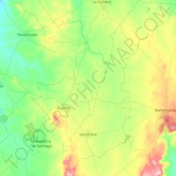
Name: Santa Ana topographic map, elevation, terrain.
Location: Santa Ana, Cáceres, Extremadura, Spain (39.27861 -6.01375 39.40615 -5.91120)
Average elevation: 474 m
Minimum elevation: 372 m
Maximum elevation: 643 m
Other topographic maps
Click on a map to view its topography, its elevation and its terrain.
Segura de León
Spain > Extremadura > Segura de León
Segura de León, Badajoz, Extremadura, Spain
Average elevation: 588 m
Badajoz
Spain > Extremadura > Badajoz
Badajoz, Tierra de Badajoz, Badajoz, Extremadura, Spain
Average elevation: 261 m
Castillejos
Spain > Extremadura > Alcántara
Castillejos, Alcántara, Cáceres, Extremadura, Spain
Average elevation: 280 m
Vegas del Ortigas
Spain > Extremadura > Medellín
Vegas del Ortigas, Medellín, Badajoz, Extremadura, Spain
Average elevation: 244 m
Toril
Spain > Extremadura > Campo Arañuelo
Toril, Campo Arañuelo, Cáceres, Extremadura, 10591, Spain
Average elevation: 273 m
Parque Nacional de Monfragüe
Spain > Extremadura > Torrejón el Rubio
Parque Nacional de Monfragüe, Calleja larga, Torrejón el Rubio, Cáceres, Extremadura, Spain
Average elevation: 351 m