
Make a donation
Phuket Province topographic map
Click on the map to display elevation.
Make a donation
Phuket Province
Although some recent geographical works refer to the sections of the Tenasserim Hills in the isthmus as the "Phuket Range", these names are not found in classical geographic sources. Besides, the name Phuket is relatively recent having previously been named Jung Ceylon and Thalang. The highest elevation of the island is usually regarded as Khao Mai Thao Sip Song (Twelve Canes), at 529 metres (1,736 ft) above sea level. However, it has been reported by barometric pressure readings that there is an even higher elevation (with no apparent name), of 542 meters above sea level, in the Kamala hills behind Kathu waterfall.
Make a donation
About this map
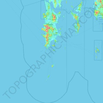
Name: Phuket Province topographic map, elevation, terrain.
Location: Phuket Province, Thailand (7.26118 98.06489 8.20219 98.49250)
Average elevation: 5 m
Minimum elevation: -1 m
Maximum elevation: 493 m
Make a donation
Other topographic maps
Click on a map to view its topography, its elevation and its terrain.
Chiang Mai
Chiang Mai has a tropical savanna climate (Köppen Aw), tempered by the low latitude and moderate elevation, with warm to hot weather year-round, though nighttime conditions during the dry season can be cool and much lower than daytime highs. The maximum temperature ever recorded was 42.4 °C (108.3 °F) in…
Average elevation: 424 m
Make a donation
Make a donation
Doi Suthep
Doi Suthep (ดอยสุเทพ), is a mountain ("doi") west of Chiang Mai, Thailand. It is 1,676 metres (5,499 ft) in elevation and is one of the twin peaks of a granite mountain. The other peak is known as Doi Pui and is slightly higher (1,685 metres (5,528 ft)).
Average elevation: 1,351 m
Make a donation
Ban Ton Pho
Thailand > Pathum Thani Province > Mueang Pathum Thani District > Bang Khayaeng Subdistrict
Average elevation: 4 m
Make a donation
Mae Salong
Thailand > Chiang Rai Province > Mae Fa Luang district
Santikhiri is a hilltop village in the Mae Fa Luang district of Thailand's Chiang Rai Province, about 80 kilometres (50 mi) from Chiang Rai. Santikhiri is on the highest peak of the Doi Mae Salong range of mountains, at an elevation of 1,134 metres (3,722 ft) above sea level. It has an alpine-like climate,…
Average elevation: 1,035 m
Make a donation
Ban Don Chuen Mu 4
Thailand > Chiang Mai Province > Saraphi District > Nong Phueng > Ban Don Chuen Mu 4
Average elevation: 300 m
Bangkok
Bangkok is in the Chao Phraya River delta in Thailand's central plain. The river meanders through the city in a southerly direction, emptying into the Gulf of Thailand approximately 25 kilometres (16 mi) south of city centre. The area is flat and low-lying, with an average elevation of 1.5 metres (4 ft 11 in)…
Average elevation: 4 m
Make a donation