
Make a donation
Krün topographic map
Click on the map to display elevation.
Make a donation
About this map
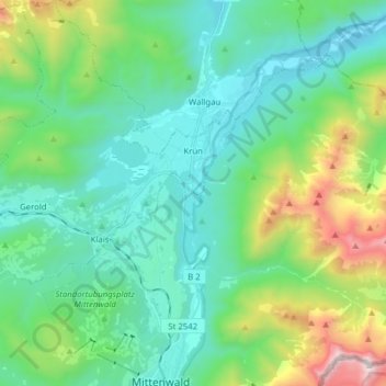
Name: Krün topographic map, elevation, terrain.
Location: Krün, Landkreis Garmisch-Partenkirchen, Beieren, Duitsland (47.44180 11.15763 47.54718 11.29596)
Average elevation: 1,198 m
Minimum elevation: 818 m
Maximum elevation: 2,455 m
Make a donation
Other topographic maps
Click on a map to view its topography, its elevation and its terrain.
Zugspitze
Duitsland > Beieren > Landkreis Garmisch-Partenkirchen > Grainau
De Zugspitze is met 2962 meter hoogte de hoogste berg van Duitsland en ligt in Zuid-Beieren, op de grens met Oostenrijk.
Average elevation: 2,300 m
Zugspitze
Duitsland > Beieren > Landkreis Garmisch-Partenkirchen > Grainau
De Zugspitze is met 2962 meter hoogte de hoogste berg van Duitsland en ligt in Zuid-Beieren, op de grens met Oostenrijk.
Average elevation: 2,300 m
Make a donation
Vordergraseck
Duitsland > Beieren > Landkreis Garmisch-Partenkirchen > Garmisch-Partenkirchen
Average elevation: 988 m