
Thank you for supporting this site ❤️
Make a donation
Make a donation
Sampont topographic map
Click on the map to display elevation.
Thank you for supporting this site ❤️
Make a donation
Make a donation
About this map
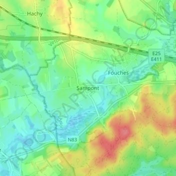
Name: Sampont topographic map, elevation, terrain.
Location: Sampont, Arlon, Luxembourg, Wallonie, 6700, Belgique (49.66459 5.67919 49.70459 5.71919)
Average elevation: 358 m
Minimum elevation: 333 m
Maximum elevation: 402 m
Thank you for supporting this site ❤️
Make a donation
Make a donation
Other topographic maps
Click on a map to view its topography, its elevation and its terrain.