
Vellerat topographic map
Interactive map
Click on the map to display elevation.
About this map
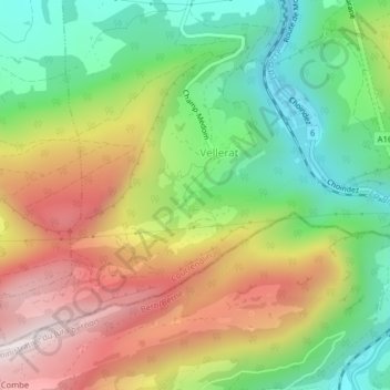
Name: Vellerat topographic map, elevation, terrain.
Average elevation: 739 m
Minimum elevation: 450 m
Maximum elevation: 1,105 m
Other topographic maps
Click on a map to view its topography, its elevation and its terrain.
Rebeuvelier
Suisse > Jura > Roches (BE) > Courrendlin
Rebeuvelier, Rue du Raimeux, La Belle Journée, Courrendlin, District de Delémont, Jura, 2830, Suisse
Average elevation: 791 m