
Hooghly topographic map
Interactive map
Click on the map to display elevation.
About this map
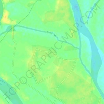
Name: Hooghly topographic map, elevation, terrain.
Location: Hooghly, Murshidabad, West Bengal, 742213, India (24.49483 88.05061 24.51335 88.09110)
Average elevation: 22 m
Minimum elevation: 12 m
Maximum elevation: 33 m
Other topographic maps
Click on a map to view its topography, its elevation and its terrain.
Serampore
India > West Bengal > Serampur Uttarpara
Serampore, Serampur Uttarpara, Hugli, West Bengal, 712201, India
Average elevation: 7 m
Basirhat
India > West Bengal > Basirhat - I > Basirhat
Basirhat, Basirhat - I, North 24 Parganas, West Bengal, 743411, India
Average elevation: 4 m
Chunchura
India > West Bengal > Chunchura
Chunchura, Chinsurah - Magra, Hugli, West Bengal, 712101, India
Average elevation: 10 m
Bangar
India > West Bengal > Bangar
Bangar, Bhangar - I, South 24 Parganas, West Bengal, 743502, India
Average elevation: 4 m
Jalpaiguri
India > West Bengal > Jalpaiguri
Jalpaiguri, West Bengal, 735101, India
Average elevation: 83 m
Bardhaman
India > West Bengal > Bardhaman
Bardhaman, Burdwan - I, Purba Bardhaman, West Bengal, 713103, India
Average elevation: 30 m