
Châteauvieux topographic map
Interactive map
Click on the map to display elevation.
About this map
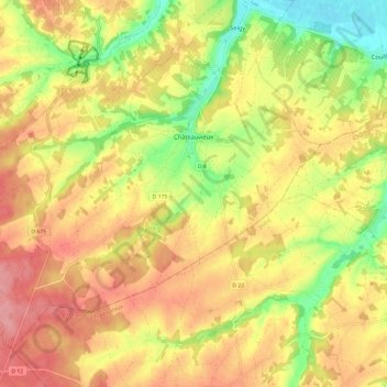
Name: Châteauvieux topographic map, elevation, terrain.
Average elevation: 123 m
Minimum elevation: 69 m
Maximum elevation: 164 m
L'altitude du territoire communal varie de 79 mètres à 160 mètres.
Other topographic maps
Click on a map to view its topography, its elevation and its terrain.
Le Petit Four
France > Centre-Val de Loire > Loir-et-Cher > Saint-Laurent-Nouan
Le Petit Four, Saint-Laurent-Nouan, Blois, Loir-et-Cher, Centre-Val de Loire, France métropolitaine, 41220, France
Average elevation: 87 m
Le Boêl
France > Centre-Val de Loire > Loir-et-Cher > Nourray
Le Boêl, Nourray, Vendôme, Loir-et-Cher, Centre-Val de Loire, France métropolitaine, 41310, France
Average elevation: 125 m
Les Rocheuses
France > Centre-Val de Loire > Loir-et-Cher > Villiers-sur-Loir
Les Rocheuses, Villiers-sur-Loir, Vendôme, Loir-et-Cher, Centre-Val de Loire, France métropolitaine, 41100, France
Average elevation: 95 m
Le Marchais Fournier
France > Centre-Val de Loire > Loir-et-Cher > Sambin
Le Marchais Fournier, Sambin, Blois, Loir-et-Cher, Centre-Val de Loire, France métropolitaine, 41120, France
Average elevation: 109 m
Vouzon
France > Centre-Val de Loire > Loir-et-Cher
Vouzon, Romorantin-Lanthenay, Loir-et-Cher, Centre-Val de Loire, France métropolitaine, 41600, France
Average elevation: 126 m
Nouan-le-Fuzelier
France > Centre-Val de Loire > Loir-et-Cher > Nouan-le-Fuzelier
Nouan-le-Fuzelier, Romorantin-Lanthenay, Loir-et-Cher, Centre-Val de Loire, France métropolitaine, 41600, France
Average elevation: 119 m
Beauce la Romaine
France > Centre-Val de Loire > Loir-et-Cher > Beauce la Romaine
Beauce la Romaine, Blois, Loir-et-Cher, Centre-Val de Loire, France métropolitaine, France
Average elevation: 128 m
Blois
France > Centre-Val de Loire > Loir-et-Cher
Blois, Loir-et-Cher, Centre-Val de Loire, France métropolitaine, 41000, France
Average elevation: 95 m