
Thank you for supporting this site ❤️
Make a donation
Make a donation
Llana Caliente topographic map
Click on the map to display elevation.
Thank you for supporting this site ❤️
Make a donation
Make a donation
About this map
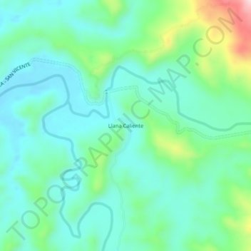
Name: Llana Caliente topographic map, elevation, terrain.
Average elevation: 211 m
Minimum elevation: 139 m
Maximum elevation: 441 m
Thank you for supporting this site ❤️
Make a donation
Make a donation
Other topographic maps
Click on a map to view its topography, its elevation and its terrain.
Serranía de los Yariguíes
Colombia > Santander > San Vicente de Chucurí > Galán
Average elevation: 1,858 m